Duchy of Brabant
|
|||||||||||||||||||||||||||
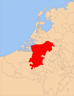
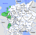
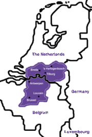
The Duchy of Brabant was a historical region in the Low Countries. Its territory consisted essentially of the three modern-day Belgian provinces of Flemish Brabant, Walloon Brabant and Antwerp, the Brussels-Capital Region and the present-day Dutch province of North Brabant.
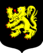
The Flag of Belgium is based of the colors of Brabant's coat of Arms: Black, Yellow, and Red.
In Roman times, the territory was situated in the Roman provinces of Belgica and Germania Inferior and inhabited by the Belgae, who were of both Celtic and Germanic origin. At the end of the Roman period they were conquered by the Germanic Franks.
The region's name is first recorded as the Carolingian shire pagus Bracbatensis, located between the rivers Scheldt and Dijle, from bracha "new" and bant "region".
Its most important cities were Brussels, Antwerp, Leuven, Breda, 's-Hertogenbosch, Lier and Mechelen.
Contents |
History
The Landgraviate of Brabant was established as a feudal imperial fief within Lower Lotharingia. As such, it was an integral part of the Holy Roman Empire. After the death of the preceding count of Brabant, Count Palatine Herman II of Lotharingia in 1085, the imperial fief was assigned to count Henry III of Leuven.
The Duchy of Brabant was formally established in 1183-1184 and the hereditary title of Duke of Brabant was created by Emperor Frederick I Barbarossa in favour of Henry I of Brabant, son of Godfrey III of Leuven. Although the original county was quite small and limited to the territory between the rivers Dender and Zenne, situated to the west of Brussels, from the 13th century on its name was applied to the entire territory under control of the dukes.
In 1190, after the death of Godfrey III, Henry I also became Duke of Lower Lotharingia. By that time the title had lost most of its territorial authority. According to protocol, all his successors were thereafter called Dukes of Brabant and Lower Lotharingia (often called Duke of Lothier).
After the Battle of Worringen in 1288, the dukes of Brabant also acquired the Duchy of Limburg and the lands of Overmaas (trans-Meuse). In 1354 the Joyous Entry, or charter of liberty was granted to the citizens of Brabant by John III.
Burgundian and Habsburg Netherlands
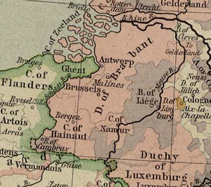
In 1430 the Duchies of Lower Lotharingia, Brabant and Limburg were inherited by Philip the Good of Burgundy and became part of the Burgundian Netherlands.
In 1477 the title fell to the House of Habsburg by dowry of Mary of Burgundy. At that time the Duchy of Brabant extended from Luttre, south of Nivelles to 's Hertogenbosch, with Leuven as the capital city. The subsequent history of Brabant is part of the history of the Habsburg Seventeen Provinces.
Eighty Years War and division of Brabant
The Eighty Years' War (1568-1648) brought the northern parts (essentially the present Dutch province of North Brabant) under military control of the northern insurgents. After the Treaty of Westphalia in 1648, the United Provinces' independence was confirmed and northern Brabant was formally ceded to the United Provinces as Staats-Brabant, a federally governed territory.
The southern part remained in Spanish Habsburg hands as a part of the Southern Netherlands. It was transferred to the Austrian branch of the Habsburgs in 1714. During the French occupation of the Southern Netherlands in 1795 the duchy of Brabant was dissolved. The territory was reorganised in the départements of Deux-Nèthes (present province of Antwerp) and Dyle (the later province of Brabant).
Cities of Brabant
The Duchy of Brabant was historically divided in four parts each with their own capital. The four capitals are Leuven, Brussels, Antwerp and 's Hertogenbosch. Before 's Hertogenbosch was founded Tienen formed the fourth capital.
The unwalled cities did not have the right to construct walls. Trade was allowed in these areas and usually this right resulted in a larger population and the development of major villages and later cities. The unwalled cities had also the right to hold markets which they held on large market squares. This distinguishes them from surrounding villages who were not allowed to hold markets and did not possess market squares. Being unwalled also meant that some of these places suffered heavely in war and during the Dutch Revolt.
Leuven quarter
walled cities
- Leuven: the capital of the original region from where Brabant expanded. It has been a university town since 1450.
- Tienen: east of Leuven. Historically it was along with Lier, Diest and Tienen one of the bigger cities after the four capitals.
- Zoutleeuw: east of Tienen. It lies near the boarder of Brabant. In time it must have been a very wealthy town. It was also the biggest garrison town near the border with Liege. A swamp separates Zoutleeuw from Liège
- Landen: south east of Zoutleeuw; small garrison town. Pepin of Landen, St. Gertrude, St. Bavo, St. Ida and St. Begga all lived south west of this city.
- Hannut: south of Landen. like Landen a small garrison town.
- Aarschot: north east of Leuven. It was the capital of the Duchy of Aarschot. It is famous for its architecture: the Demer gothic which uses a local type of red stone for its churches and other important buildings
- Scherpenheuvel: east of Aarschot. It was the only baroque town in the Netherlands and it is still an important place of pilgrimage.
- Zichem: north of Scherpenheuvel. The city was destroyed during the Dutch revolt giving it a rural character ever since. The church and the Maagdentoren (tower of the Virgin) in local red stone are impressive buildings from Zichem's past. Zichem was part of the Barony of Diest.
- Diest: east of Scherpenheuvel. It was one of Brabants biggest cities after the four capitals and an important brewery town. The city still counts numerous monuments today. Like Zichem and Breda it is a Nassau city. Diest is also the capital of the Barony of Diest
- Halen: A small garrison city where the "Battle of the Iron Helmets" took place during World War I: a victory for the Belgian Cavalry
- Jodoigne: south of Tienen. The city and the surrounding area is known for its white stone which gives the whole area a picturesque character. Although many battles took place in this area and other parts of Walloon Brabant
- Gembloux: south of Jodoigne. Is known for Gembloux Abbey
unwalled cities
- Wavre: west of Jodoigne and today the capital of Walloon Brabant
- Dormaal: south of Zoutleeuw. Although it holds city rights it never really developed into a city and could be considered a village.
Brussels quarter
walled cities
- Brussels: the capital of this part of Brabant. Former capital of the Seventeen Provinces, the Southern Netherlands and today capital of Belgium. Known as the city of nobles because of the presence of the court.
- Vilvoorde: north of Brussels. The first prison of the Southern Netherlands was build here under Austrian rule.
- Nivelles: south of Brussels. Known for its church and Gertrude of Nivelles who played an important role in the early history of Brussels and the region.
unwalled cities
- Braine-l'Alleud: south of Brussels. The battle of Waterloo took place near this city. The church functioned as a hospital
- Genappe: east of Nivelles; a small city with an old centre developed around a market square
- La Hulpe: north east of Braine Alleud. Could be considered a village, although it was allowed to hold markets and held justice in its own domain. It became more important lately as the residence of Solvay
- Overijse: south west of Brussels. Historically more important, it held an own Béguinage and cloth hall but the city never much expanded beyond the large market square
- Tervuren: east of Brussels. Tervuren was the residence of the Dukes of Brabant and later the local Habsbourgs country residence. Residences of nobles caracterise Tervuren. Also the Congo-museum is situated in the park of Tervuren
- Duisburg: south east of Tervuren; was ruled by the abbey of Coudenberg. It never developed into a city
- Merchtem: north west of Brussels. A rather small unwalled city but bigger then La Hulpe or Duisburg
- Asse: West of Brussels. Next to Genappe and Braine Alleud one of the bigger unwalled cities of the Brussels quarter. It holds an old hospital and market square.
Antwerp quarter
walled cities
- Antwerp: the capital of this quarter. Also the Episcopal see for this part of Brabant which includes de Barony of Breda and the Margrave of Bergen op Zoom. Antwerp is a city of merchants with many merchant palaces build in this city
- Lier: south east of Antwerp. Known for the wedding of the parents of Charles V.
- Herentals: east of Lier. A city in a forest area
- Zandvliet: north of Antwerp. A garrison city to defend the Southern Netherlands
- Bergen op Zoom: north of Zandvliet. Port town
- Steenbergen: north of Bergen op Zoom; also an important port town
- Breda: north east of Antwerp. One of the Nassau cities
unwalled cities
- Turnhout: north of Herentals. The largest of the unwalled cities of Brabant
- Geel: east of Herentals. Known for its health care
- Hoogstraten: north east of Antwerp. Capital of the county of Hoogstraten
- Duffel: south of Antwerp. More illustrious in the past then it is today. An important barony which was mostly destroyed by wars.
- Walem: part of the barony of Duffel; never became bigger than a village
- Arendonk: east of Turnhout. Famous for training falcons and eagles for hunt.
Note: the city of Mechelen formed an independant state along with the Land of Heist-op-den-Berg and Gestel. Willemstad, Geertruidenberg and Klundert were part of the County of Holland.
's Hertogenbosch quarter
walled cities
- 's Hertogenbosch (= Den Bosch): capital and bishop city of this part of Brabant.
- Heusden: north west Den Bosch : is said to be the untakable city and lies close to the county of Holland and Gelderland.
- Helmond: east of Eindhoven: was build to function as a counter weight to the counts of Gueldres. It has a massive water fortress
- Ravestein: east of Den Bosch
- Meghem: north of Ravestein
- Grave : south of Ravestein: These three cities are the garrison towns of the North east of Brabant
unwalled cities
- Oirschot
- Oisterwijck
See also
- Dukes of Brabant
- Dukes of Brabant family tree
- War of Devolution (1667 – 1668)
|
||||||||||||||||||||